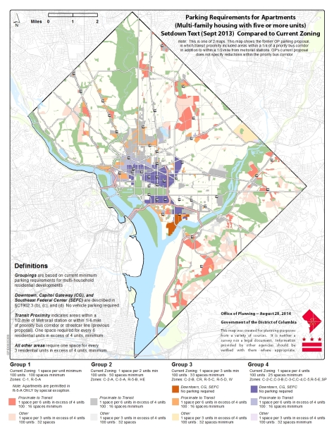
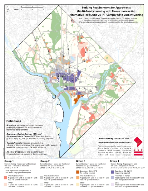
The following maps prepared by OP for the Friendship Heights Neighborhood Association, provide an illustration of the ZRR parking proposal. The first map compares the current regulations to the proposal which was setdown by the Zoning Commission in September 2013, and the second map compares the current regulations to the alternative proposal setdown in June, 2014. While they are similar to maps that OP has already provided to the Zoning Commission and uploaded to this site, they specifically focus in on multi-family residential development. The difference between the two maps is that:
• under the 2013 proposal, a parking reduction of 50% would be permitted by-right for new development proximate (within ¼ mile) of a WMATA Priority Bus Corridor;
• under the 2014 alternative, OP is not proposing the 50% parking reduction for new development proximate to a Priority Bus Corridor.
(click to enlarge)


Like any map, there are some generalizations – for example, the maps do not take into account areas that are subject to site specific review and parking requirements, such as university campus plans or Planned Unit Developments. The maps also do not distinguish R-5-A zoned land that is not developed with apartments (in R-5-A, a new apartment building is permitted only by special exception so would receive BZA, ANC, and community review) – much of the R-5-A zoned land is developed with one-family dwellings or flats, where the parking requirement would remain 1 parking space per building, with no reduction for proximity to transit.
Of course, OP also proposed other alternatives to the September 2013 text as part of the June 2014 alternatives – a complete description is provided below, or you can read the OP report on the Office of Zoning website (link), case 08-06A, Exhibit 725. The Zoning Commission will be holding public hearings on these alternatives, September 8 – 11; you can attend an provide comments or submit written comments to the record via the Office of Zoning website, prior to September 15, 2014.
Would it be possible for you to add links to the higher resolution versions of these maps?